
................................................................................................................................................................................................................................................................................................................................................................................................................................................................................................................

Copyright © visitindia.org.in. All Rights Reserved.

Travelogues/Travel Logs of Roadtrips
Hit the road with the summary guides of our trips to various places in India. Any information feel free to drop a mail at info@visitindia.org.in


Get online driving directions, route guides, weekend planners, and customised itineries. Check out a few of our favorite user road trips, then start an adventure of your own.....Explore India by Road

Find us :-
Morena
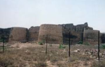
Chambal Ravines, Morena


Situated between the Chambal and the Kwanri rivers, Morena is the headquarters of Chambal division. Its past goes back to pre-historic age. The rock paintings found in the hills of Pahargarh are evidence of it. In the Mahabharat Age, there were two important places named Shantanukheda and Kuntalpur. Shantanukheda is located on the bank of the Chambal where remains of a large number of brick-built buildings have been found. Kuntalpur is situated on the bank of Kwanri river and is the believed birthplace of Pandava's mother Kunti. Remains of the Mahabharat Age have been found there.
After the Mauryans, the territory came under the possession of the Nagas and then the Guptas. The temples of Paroli date to the post-Gupta period. After the Guptas, the territory was under the Pratiharas. Yashovarman and Amaraj built 23 temples at Naresar in this period of great temple building activity. At the same time, hundreds of temples were built at Bateshwar. Subsequently, the Kachchhapaghatas ruled over the territory. They built temples at Eiti, Varahawali, Ardoni, Mitawali, Amledha, Bhensora and Suhania. Of these, the temples of Kakan Math, Padhawali and Mitawali are remarkable. The Tomars of Delhi defeated the Kachchhapaghatas and established their rule at Eisah before shifting to Gwalior. They built a fortress on the bank of Chambal at Eisah. Distance from Gwalior 35k.m.
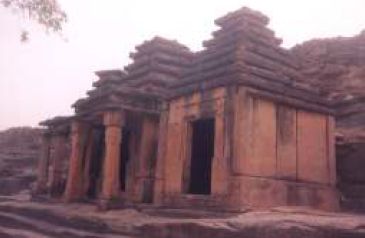
Group of Temples in Naresar
The door-jamb of temple No. 19 has a word "Naleshwar" (Naleshwar Devay, Dev Naleshwaray) engraved on it. Naleshwar is an epithet of Lord Shiva, to whom the temple is dedicated. Among the group of temples at Naresar, temple No. 17 was built by Yashovarman (725-52 A.D.). Yashovarman's son Amaraj built temples No.18, 19, 20 and 23, was built by Pratihara ruler Vatsaraj (770-805 A.D.).
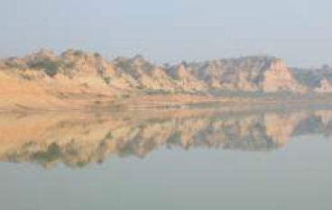
Situated 80 kms from Agra in an area bordering Rajasthan, Uttar Pradesh (UP) and Madhya Pradesh (MP), along the Chambal river, is an area where dacoits thrived in 1970s and 1980s. The Chambal Ravines are a rocky terrain located near the Vindhya Range of mountains, has deep and narrow gorges, at some places covered by thick growth of greenery and at other places the loose topsoil eroded by rain and ravages of wind and harsh weather. The name Chambal Ravines is derived from the River Chambal, a tributary of River Yamuna.
With a rich heritage stretching back many millennia the Chambal Valley has much to offer from its stunning landscapes & magnificent wildlife, formidable fortresses & crumbling ruins, tranquil temples & flamboyant fairs, colourful history & compelling mythology, a proud resilient people & their legendary exploits. The Chambal Safari helps visitors discover the many facets of this ancient land. Accompanied by experienced local guides and naturalists, guests may explore the Chambal Valley at their own pace: on boats, jeeps, The confluence is dominated by the ruins horses, bicycles or on foot.
Apart from bird watching and river safari the ravines are an ideal site for adventure lovers. Chambal experience could easily be combined with any visit to Agra for the Taj Mahal and / or trips to Orchha / Khajuraho.
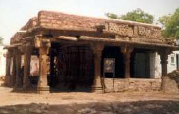
Padhawali temple
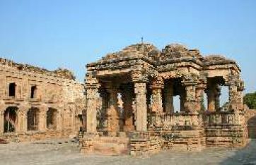
Padhawali is situated about 14 km from Malanpur on Malanpur-Morena road. After Naga period, the Gupta empire was established in this area. The 'Gotra' of the emperors of the Gupta dynasty was 'Charan'. 'Gharon' village was inhabited near modern Padawali. Around Gharon there are the ruins of several temples, houses and colonies. This new area of population is known as Padawali because it is surrounded by several hills. More than fifty monuments of different kinds can be seen at Padawali upto the valley of Bhuteshwar.
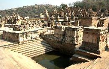
Mitawali Temple
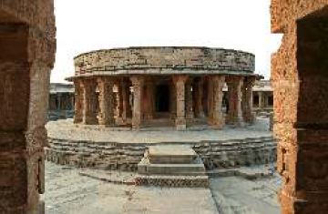
Mitawli (40km via Malanpur ), the temple stands on a circular platform in an open court enclosed by a circular wall with small cells and colonnade inside with a Shiva image in each cell. It is dated to the 14 century A.D. On the basis of an inscription dated to V.S.1380(1323 ad.) it can be claimed that the temple was built by the erstwhile ruler Maharaja Devapala. The design is believed to inspire the construction of the Parliament house at New Delhi.
Forts
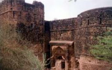
The fortress is located at Padhawali about 12 km from Malanpur on the left side of Malanpur-Morena road. The fortress was built by the Jat Ranas of Dhaulpur in the first half of the 18th century A.D. on a large platform of Kachchhapaghata period.
_____________________________________________________________________________________________________________________________________________________________________________________
Padhawali fort
Sumawali Fort
This fortress is situated about 17 km from Noorabad on Agra Bombay road on the right side. The fortress and palace were built by later Mughals. Only main gate of the fortress has survived and the defence wall has been destroyed. The entrance gate is very huge in which lakhori bricks were used. The palace is small having a pillared spacious room and small rooms built on both sides. Similarly, rooms are built on the second storey.
Eiti Sun temple
Situated 2k.m. from Rethaurakalan this west-facing temple was built in 11-12th century A.D. in Kachchhapghat style. Pillared mandaps are built on all four sides. Images of river goddess Ganga and Yamuna are carved on both jambs of the gate. The lalat bimb has the Sun god carved in the middle and is flanked by idols of Uma Maheshwar. The temple also has a depiction of Saptamatrikas. The roof of the temple is flat.
The temple of Bateshwar
Nestled in the foot of a forested hill Bateshwar is 2 Km. south of Padhavali village in district Morena. Although only 25 kms. away from its district headquarters, the site remained inaccessible for general public being a hide out for the dacoits, until recently. With the taking over of the sacred place by Archaeological Survey of India, in 1988 the place again received attention after lying dormant for more than eight hundred years. However, it was not always so, as Bateshwara was a cultural oasis of eminence that provided nourishment and continuity to temple architecture for well over 300 years.
Here, it remains a mystery that how this enclave stood its ground for so many years? Perhaps it was as culmination of resurgent aspirations of the people in the post-Gupta times, which incidentally enabled the passing on of vibrant traditions of temple architecture. The hub of this site of over 40 extant temples is the Bhutesvara Mahadeva temple from which the place gets its name.